MISSOURI, USA — The Weather First team issued a Storm Alert as severe thunderstorms passed through the St. Louis region Friday afternoon and evening.
5 On Your Side will provide live updates as storms move through the St. Louis area. For the latest forecast, click here.
10:04 p.m. - Severe Thunderstorm Warning issued for part of the St. Louis area until 10:45 p.m. Areas include Edwards, Franklin, Hamilton, Jefferson, Saline, Wayne, and White counties in Illinois.
9:48 p.m. - Tornado Watch for Bond, Clinton, Fayette, Madison, Marion, Monroe, Montogomery, Randolph, St. Clair, Washington counties in Illinois and Ste. Genevieve in Missouri is expired.
9:33 p.m. - Severe Thunderstorm Warning for part of the St. Louis region until 10:15 p.m. Areas include Franklin, Jackson, Jefferson, Perry, and Williamson counties in Illinois.
9:17 p.m. - Severe Thunderstorm Warning for part of the St. Louis area in effect until 9:30 p.m. Areas include Clay, Coles, Cumberland, Douglas, Effingham, Moultrie, Shelby counties in Missouri.
8:59 p.m. - High Wind Warning for Adams, Brown, Pike counties in Illinois and Audrian, Boone, Callaway, Knox, Lewis, Marion, Monroe, Pike, Ralls, Shelby counties in Missouri is expired.
8:58 p.m. - A Hazardous Weather Outlook is issued by the National Weather Service St. Louis for portions of eastern and central Missouri as well as west central and southwest Illinois.
8:48 p.m. - Wind Advisory continues until 1 p.m. on Apr. 1 for the St. Louis Metro area and southern Illinois region.
8:47 p.m. - Wind Advisory for Adams, Brown, Pike, Randolph, Illinois and Crawford, Iron, Madison, Reynolds, St. Francois, Ste. Genevieve, Washington, Audrain, Boone, Callaway, Knox, Lewis, Marion, Monroe, Pike, Ralls, Shelby in Missouri until 1 p.m. on Apr. 1.
8:45 p.m. - Severe Thunderstorm Warning for Fayette, Illinois is canceled.
8:45 p.m. - Tornado warnings for Clay and Effingham counties in Illinois are expired.
8:33 p.m. - Tornado warning canceled for Marion County in Illinois.
8:21 p.m. - Tornado warning issued for Clay and Effingham counties in Illinois until 8:45 p.m. Tornado warning continues in Marion County until 9 p.m.
7:14 p.m. - Severe Thunderstorm Warning expired for Bond, Clinton, Madison counties in Illinois.
6:55 p.m. - Pea-sized hail reported in Northeastern Shiloh and Lebanon in St. Clair County, Illinois.
6:42 p.m. - Severe thunderstorm warning canceled for Jefferson County in Missouri. Warning continues in Monroe, Bond, Clinton, Madison and St. Clair counties in Illinois until 7:15 p.m.
6:31 p.m. - Severe thunderstorm warning canceled for St. Francois and Ste. Genevieve counties in Missouri. Warning continues in Monroe County in Illinois and Jefferson County in Missouri until 7:15 p.m.
6:28 p.m. - NWS issues a severe thunderstorm warning for Bond, Clinton, Madison and St. Clair counties in Illinois until 7:15 p.m.
6:26 p.m. - Severe thunderstorm warning issued for Jefferson, St. Francois and Ste. Genevieve counties in Missouri, Monroe County in Illinois until 7:15 p.m.
6:10 p.m. - No active tornado warnings in the St. Louis area. The threat remains over the next few hours and wind gusts over 60 mph possible overnight.
6:09 p.m. - Golf ball sized hail was reported in Bowling Green, Missouri after storms pass through the area.


5:55 p.m. - Hail reported in Troy, Missouri.

5:45 p.m. - Tornado warning canceled for Calhoun County in Illinois, tornado warning expired for Greene County in Illinois.
5:39 p.m. - Severe thunderstorm warning canceled for Crawford County in Missouri. Severe thunderstorm warning continues in Washington County in Missouri until 6:15 p.m.
5:32 p.m. - NWS issues severe thunderstorm warning for Crawford and Washington counties until 6:15 p.m. The storm has radar-indicated hail of 1 inch.
5:27 p.m. - Tornado warning canceled for Jersey County in Illinois, Lincoln and Pike counties in Missouri. Tornado warning continues in Calhoun and Green counties in Illinois until 5:45 p.m.
5:22 p.m. - NWS issues a tornado warning for parts of Crawford, Franklin and Washington counties until 6 p.m.
5:12 p.m. - Tornado warning canceled in Gasconade County in Missouri. Tornado warning continues in Crawford, Franklin and Washington counties until 6 p.m.
5:11 p.m. - NWS issues severe thunderstorm warning for Calhoun, Greene and Pike counties in Illinois, Pike County in Missouri until 6 p.m.
5:05 p.m. - NWS issues tornado warnings for Calhoun, Green and Jersey counties in Illinois, Lincoln and Pike counties in Missouri until 5:45 p.m.
5:01 p.m. - Severe thunderstorm warning canceled for Pike County in Missouri.
4:58 p.m. - NWS issues tornado warnings for Crawford, Franklin and Gasconade counties in Missouri until 5:45 p.m.
4:53 p.m. - NWS issues a tornado warning for Phelps County in Missouri until 5 p.m.
4:45 p.m. - NWS issues severe thunderstorm warning for Phelps County in Missouri until 5:15 p.m.
4:42 p.m. - NWS issues severe thunderstorm warning for Lincoln, Montgomery and Pike counties in Missouri until 5:30 p.m. The storm has radar-indicated winds of 60mph and radar-indicated hail of 1 inch.
4:29 p.m. - NWS issues severe thunderstorm warning for Pike County in Missouri until 5:15 p.m.
3:58 p.m. - NWS issues severe thunderstorm warning for Pike, Montgomery and Audrain counties in Missouri until 4:45 p.m. The storm will contain golf ball sized hail.
3:47 p.m. - Scattered strong and severe thunderstorms are rotating over parts of mid-Missouri. Strong winds, hail and tornado threats exist.
3 p.m. - Severe thunderstorm warning canceled for Cape Girardeau and Perry counties in Missouri, Jackson and Union counties in Illinois.
2:45 p.m. - Severe thunderstorm warning canceled for Clay, Effingham and Jasper counties in Illinois.
2:29 p.m. - NWS issues severe thunderstorm warning for Cape Girardeau and Perry counties in Missouri, Jackson and Union counties in Illinois until 3 p.m.
2:16 p.m. - NWS issues severe thunderstorm warning for Clay, Effingham and Jasper counties in Illinois until 2:45 p.m. The storm will contain golf ball sized hail.
Download the free 5 On Your Side app to get the latest watches and warnings and track conditions live with our interactive radar. Use the links below to download now.
5 On Your Side news app
iPhone | Google Play
1:43 p.m. - Severe thunderstorm warning canceled for Crawford County. The warning remains in effect until 2 p.m. for Washington County.
1:35 p.m. - Severe thunderstorm warning canceled for Iron County. The warning remains in effect until 2 p.m. for Washington and Crawford counties.
1:20 p.m. - NWS issues severe thunderstorm warning for Crawford, Iron and Washington counties in Missouri until 2 p.m. The storm will contain golf ball sized hail.
12:27 p.m. - NWS issues a tornado watch for parts of Missouri and Illinois until 8 p.m., including the following counties:
- Missouri: Crawford, Franklin, Iron, Jefferson, Madison, Perry, Phelps, Pike, Reynolds, St. Charles, St. Francois, St. Louis, St. Louis City, Ste. Genevieve, Warren, Washington.
- Illinois: Bond, Calhoun, Clinton, Fayette, Greene, Jefferson, Jersey, Macoupin, Madison, Marion, Monroe, Montgomery, Randolph, St. Clair, Washington.

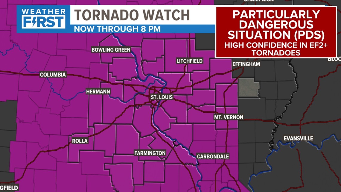
11:47 a.m. - National Weather Service issues a particularly dangerous situation tornado watch for portions of northern and central Missouri and western Illinois until 8 p.m. Friday.
A potent area of low pressure is making its way into the Great Plains Friday morning. It has produced heavy rain, gusty winds and mountain snow since it moved in from California.
That system is heading our direction.
The first round of showers moved through early Friday morning. Those storms were not severe, but now that they have moved on, we'll have a dry rest of the morning. With sunshine getting through the clouds Friday morning, that could mean thunderstorms reach their full potential later Friday afternoon and evening.
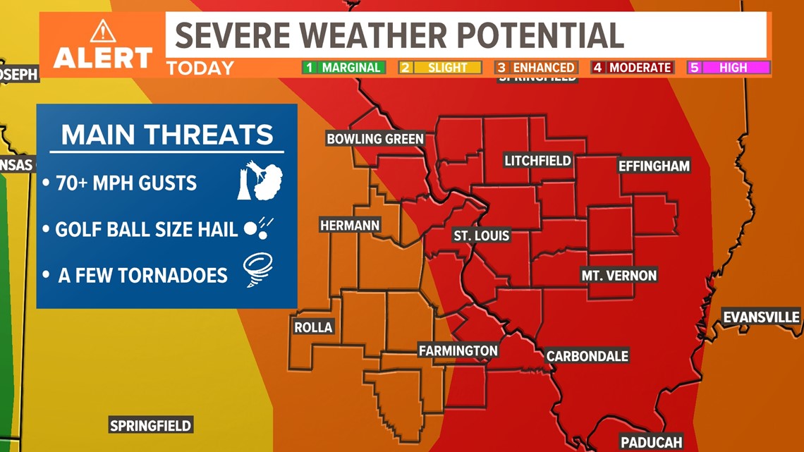
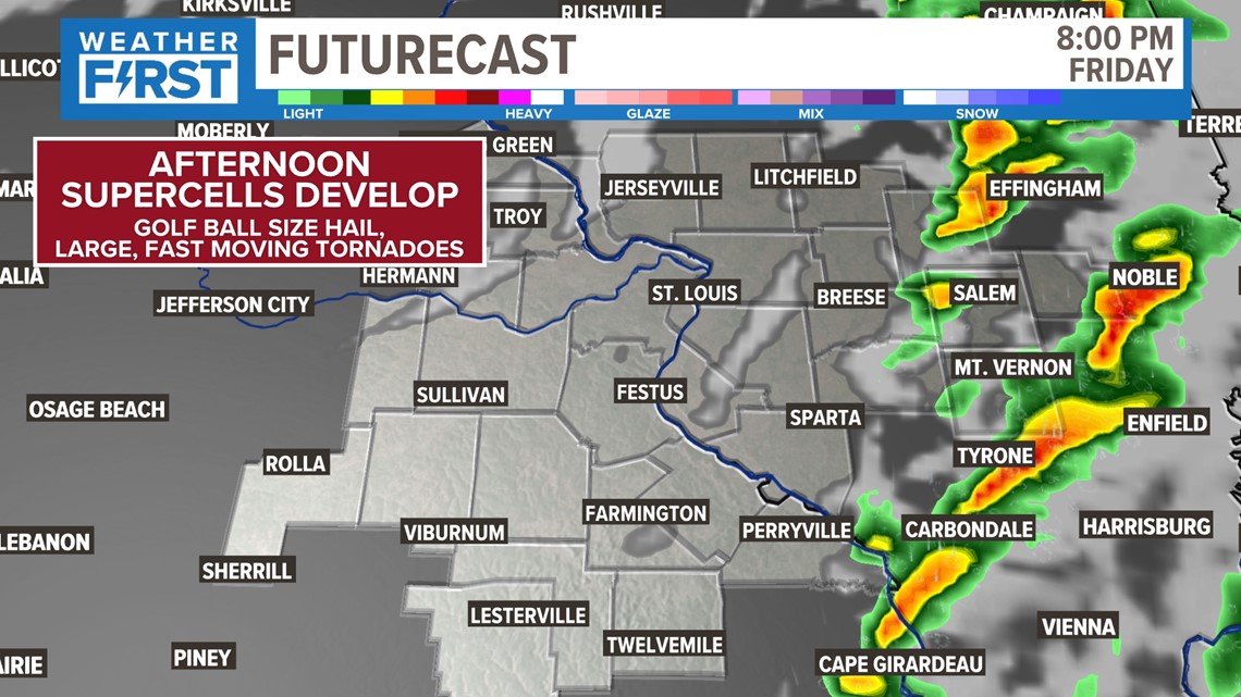
The storms that form this afternoon have the potential of putting down large hail, the size of golf balls. Even gusts over 70 mph are possible along with a tornado or two. The greatest threat is from 2 p.m. until 8 p.m.

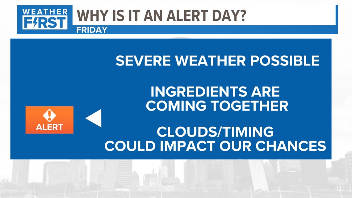
Early Friday morning the Storm Prediction Center upgraded the St. Louis area into a moderate risk of severe weather Friday afternoon and evening. The confidence is increasing that we could have several storms in the 5 On Your Side viewing area possible of producing dangerous, life-threatening weather through the afternoon and evening.

The first storms should form around lunchtime and thereafter. Thunderstorms should become more widespread as the afternoon rolls along.

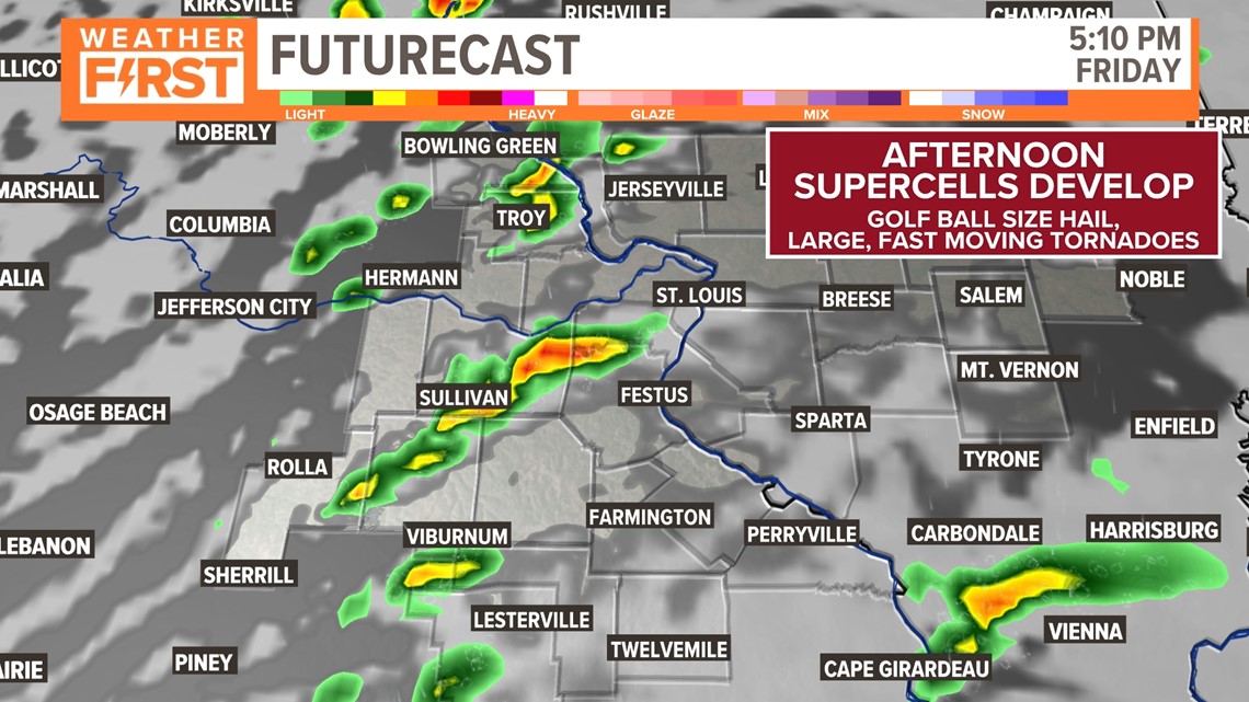
These storms will be moving fast and could drop a tornado or two very quickly. If any tornadoes do form, they have the potential of becoming long-tracked, large tornadoes. At the onset of the storm development large hail is also possible.

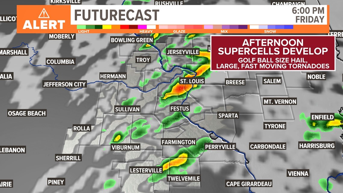
As the storms push eastward, they should form into a line and that line will have the potential of producing damaging, gusty winds over 70 mph, especially in Illinois.

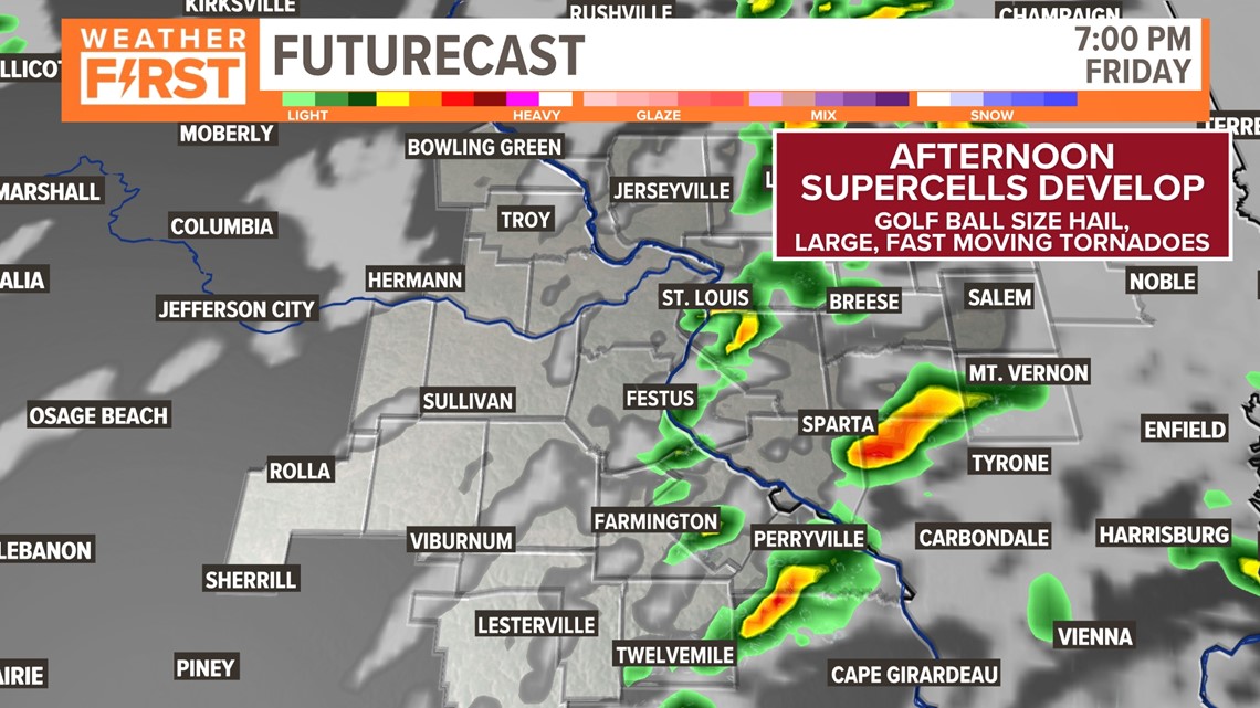
The fast-moving storms will be racing northeast during the evening and should be out of our area by 10 p.m. at the latest.

As this weather system pulls away, gusty winds will turn to the northwest. The strongest winds will be overnight Friday into early Saturday.

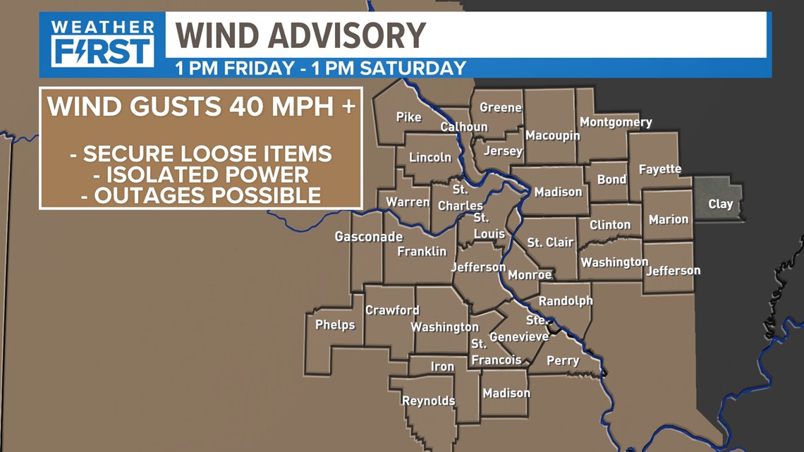
A wind advisory is in effect during this time for widespread wind gusts above 40 mph.
In Missouri, we serve these counties: Crawford County, Franklin County, Gasconade County, Iron County, Jefferson County, Lincoln County, Madison County, Perry County, Phelps County, Pike County, Reynolds County, St. Charles County, St. Francois County, St. Louis City, St. Louis County, Ste. Genevieve County, Warren County and Washington County.
In Illinois, we serve Bond County, Calhoun County, Clay County, Clinton County, Fayette County, Greene County, Jefferson County, Jersey County, Macoupin County, Madison County, Marion County, Monroe County, Montgomery County, Randolph County, St. Clair County and Washington County.