ST. LOUIS — Wednesday was our warmest day of the week with sunshine our highs made it into the low 40s. It was the first day above freezing in St. Louis since last Friday, Jan. 12. It also was the first day above 20 degrees since last Saturday afternoon Jan. 13.
Thursday STL-Lambert was well above freezing and in the low 40s before our 2nd round of Arctic air pushes through the St. Louis area tonight.
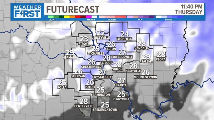
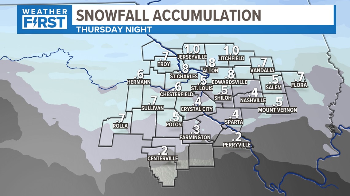
The best chance to see more minor accumulations of snow will be overnight Thursday into the wee hours of Friday. Any snow, other than a few flurries, should be out of our area by daybreak. A dusting to an inch of snow is possible. The higher amounts likely falling north of Interstate 70.
As temperatures drop into the teens, any snow that falls will stick. With a gusty wind, the snow will blow around and hopefully off the roads.
The light accumulating snow will begin later Thursday evening, lasting about three to five hours.
The light snow comes to an end well before sunrise Friday.

With a gusty wind on Friday, wind chill readings will be below zero all day. But with this next resurgence of frigid air, the lower wind chill readings look to be Saturday morning when the feels-like temperature will be 10 below zero.
Another Wind Chill Advisory has been issues west of the metro in Missouri for Pike, Lincoln, Warren, Gasconade and Phelps counties from early Friday through noon Saturday for wind chill readings as low as -25. The St. Louis metro and the rest of the 5 On Your Side viewing area has a Wind Chill Advisory from 6 p.m. Friday until noon Saturday for wind chill readings as low as -20.


Please remember: Dangerously cold wind chill readings could cause frostbite on exposed skin in as little as 30 minutes. Avoid outside activities if possible. When outside, make sure you wear appropriate clothing, a hat and gloves.
As the 5 On Your Side Weather Team says, dress in layers.


Afternoon high temperatures on Saturday will only be in the teens with low wind chill readings. Continue to dress in layers.

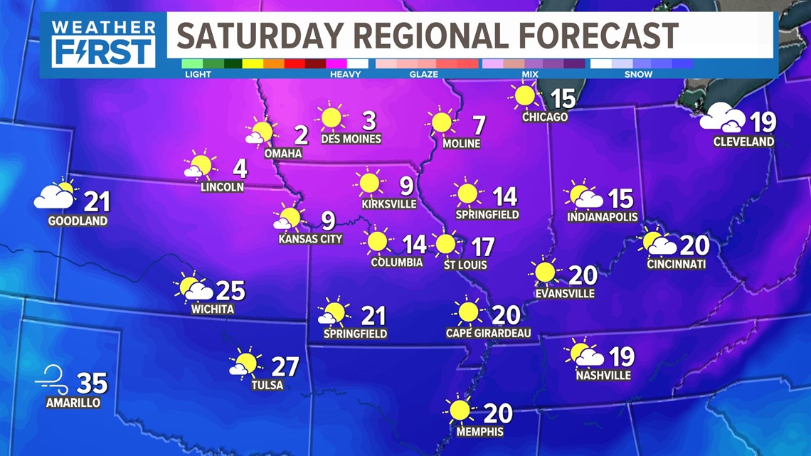
On Sunday, we hope to reach 30 degrees as milder air begins to move into the area.
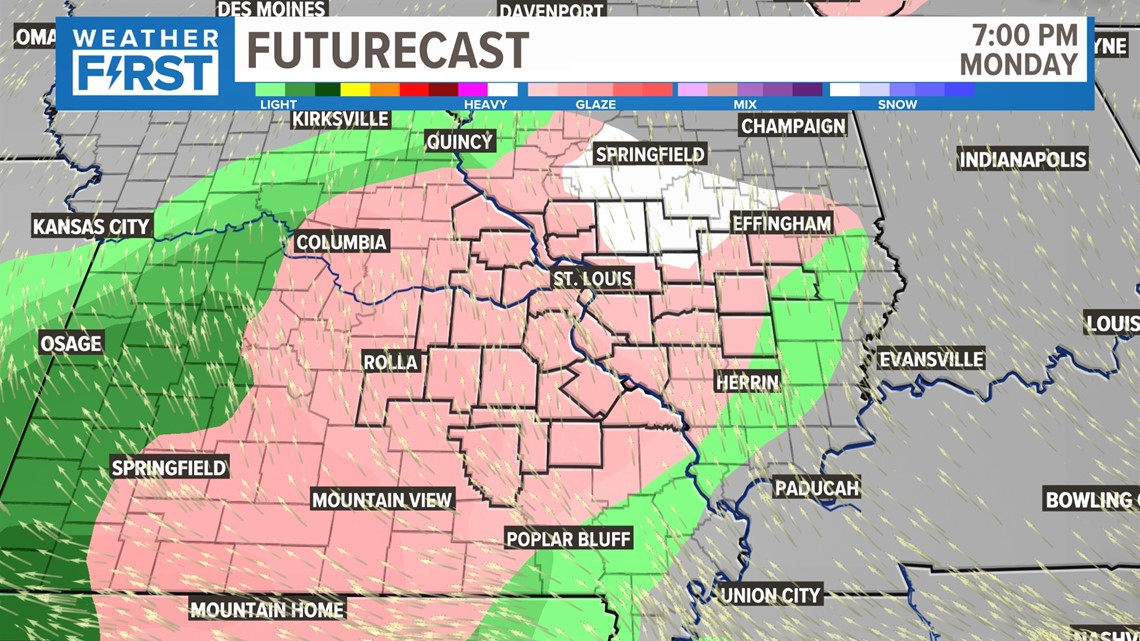
On Monday, after a cold start in the 20s, freezing rain is possible before high temperatures climb into the mid-30s.
After Monday, we do expect to see only rain next week with highs in the mid to upper 40s, possibly low 50s and lows staying above the freezing mark.

To watch 5 On Your Side broadcasts or reports 24/7, 5 On Your Side is always streaming on 5+. Download for free on Roku, Amazon Fire TV or the Apple TV app store.