ST. LOUIS — The Weather First team issued a Storm Alert for severe storms in the St. Louis area Wednesday. A severe thunderstorm watch for a section of the metro area expired at 12 p.m.
A fatal tornado struck a region south of the St. Louis area. Read about the storm in Bollinger County here.
1:03 p.m. Severe thunderstorm warnings expired for the region. One county in the 5 On Your Side coverage area remained under a tornado watch until 4 p.m.: Jefferson County, Illinois.
10:43 a.m. Meteorologist Jim Castillo planned to end Storm Alert at about 12:30 p.m.
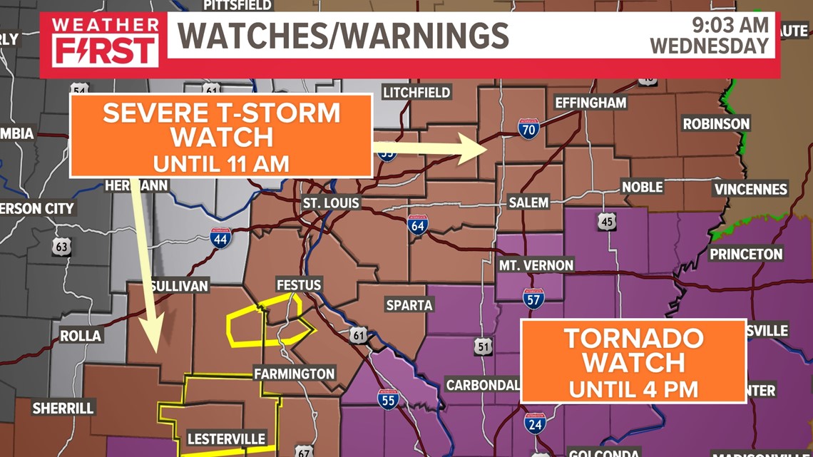
9:03 a.m. Latest updated watches: Severe Thunderstorm Watches in place until 11 a.m. and Tornado Watch is well southwest. Most of the severe weather threat is winding down this morning, especially once the wind shifts and front moves out

9:00 a.m. Severe thunderstorm warnings remain in place for Reynolds and Iron counties until 9:30 a.m. Wind gusts up to 60 mph and quarter sized hail are possible.

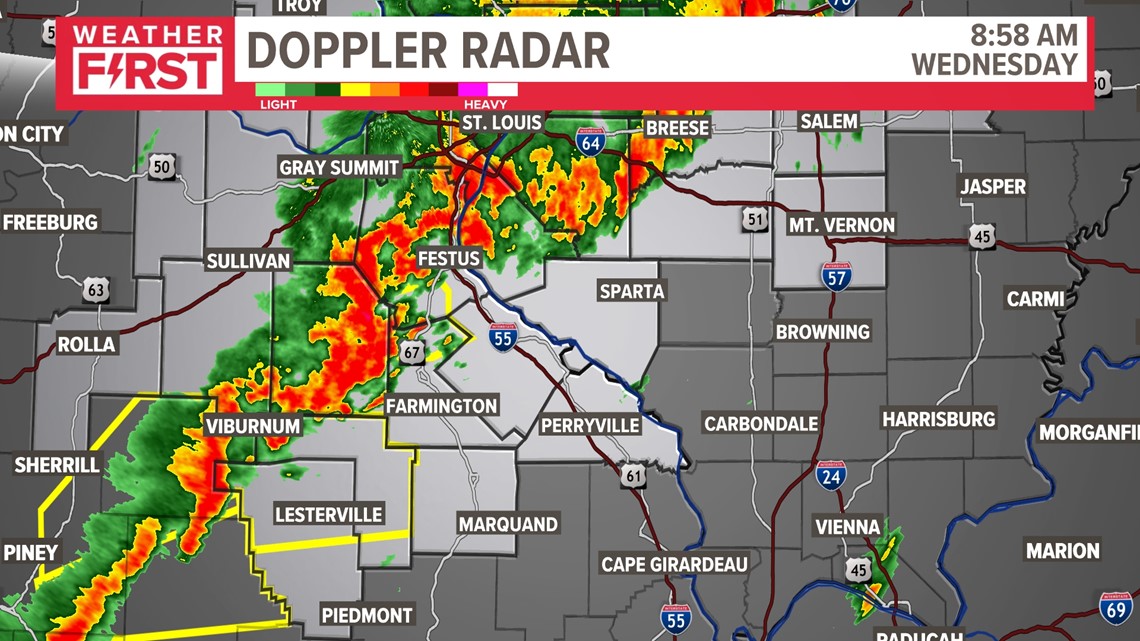
8:40 a.m. - Severe thunderstorm warning issued for Jefferson, St. Francois, Washington counties until 9:30 a.m. Wednesday. Winds up to 60 mph and three-quarter inch hail are possible.
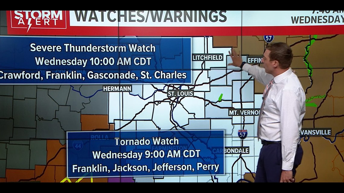
8 a.m. - A tornado watch remains in effect for Franklin, Jackson, Jefferson and Perry counties until 9 a.m. Wednesday.
A thunderstorm watch remains in effect for Crawford, Franklin, Gasconade and St. Charles counties until 10 a.m.

6:50 a.m. - NWS cancels the severe thunderstorm watch in place for the following counties:
- Illinois: Calhoun and Greene.
- Missouri: Lincoln, Marion and Warren.
NWS also expires the wind advisory in place for the following counties:
- Illinois: Bond, Calhoun, Clinton, Fayette, Greene, Jersey, Macoupin, Madison, Marion, Monroe, Montgomery, St. Clair and Washington.
- Missouri: Franklin, Gasconade, Jefferson, Marion, Monroe, Lincoln, Warren, St. Charles, St. Louis and St. Louis City.
Download the free 5 On Your Side app to get the latest watches and warnings and track conditions live with our interactive radar. Use the links below to download now.
5 On Your Side news app
iPhone | Google Play
5:50 a.m. - Severe thunderstorm warning has been canceled for Greene and Calhoun counties.
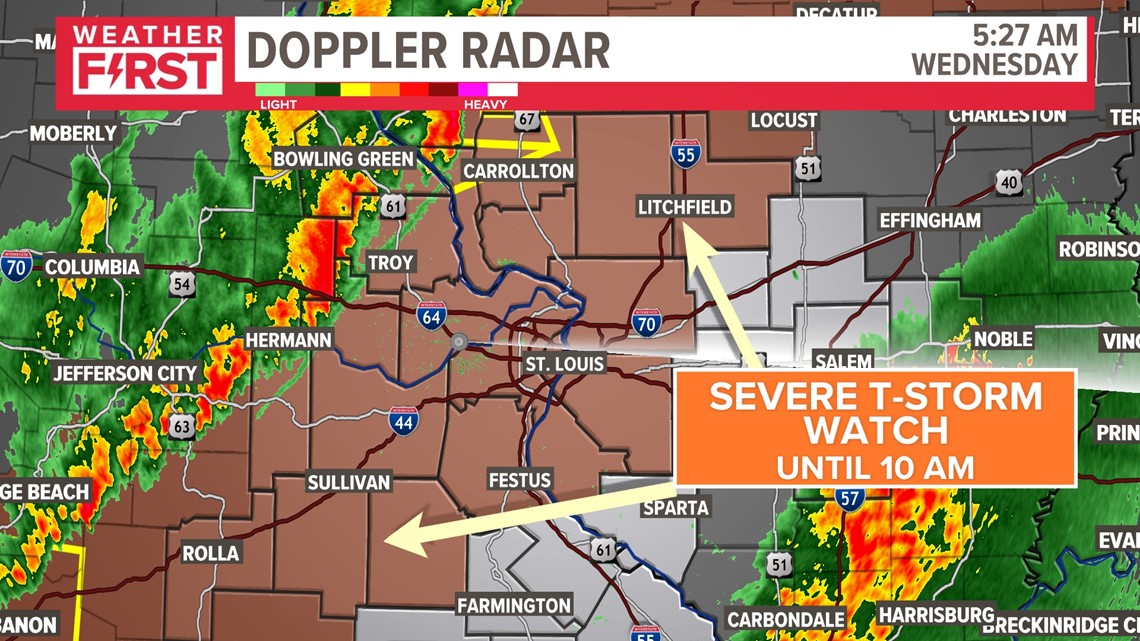
5:30 a.m. - Severe thunderstorm watch is in place for St. Louis and parts of the Metro East until 10 a.m. Wednesday. Wind gusts up to 60 mph and quarter size hail are possible throughout the morning.

5:10 a.m. - Severe thunderstorm warning is issued for Calhoun County, Illinois; Greene County, Illinois; and Pike County, Missouri, until 6 a.m. Wednesday.
5:04 a.m. - Report of pea size (quarter-inch) hail in Bowling Green, Missouri.
4:30 a.m. - NWS issues severe thunderstorm warning for Pike County, Missouri, until 5:15 a.m. Wednesday. Radar indicates hail up to an inch and wind gusts up to 60 mph.
3:40 a.m. - Tornado warning is canceled for Madison County, Missouri.
3:30 a.m. - NWS issues a tornado warning for Madison County, Missouri, until 4 a.m. Wednesday.
2:30 a.m. - National Weather Service issues a tornado watch until 9 a.m. Wednesday for the following counties:
- Illinois: Randolph.
- Missouri: Iron, Madison, Reynolds, St. Francois and Ste. Genevieve.
NWS also issues a severe thunderstorm watch for parts of the St. Louis area until 10 a.m. Wednesday. The following counties are included:
- Illinois: Calhoun and Greene.
- Missouri: Pike, Lincoln, Warren, St. Charles, Gasconade, Franklin, Crawford and Phelps.
It's severe weather season, and our forecast reflects that. Once again, the 5 On Your Side coverage area could see tornadoes, hail and strong winds.
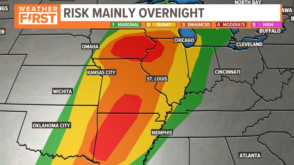
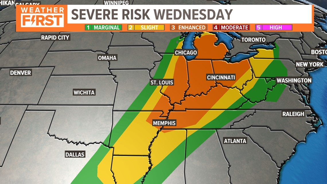
The Storm Prediction Center, a division of the National Oceanic and Atmospheric Administration and partner with the National Weather Service, has issued an enhanced risk for severe storm development for much of the region.
We aren't alone. Like Friday, we join the rest of the Midwest in anticipation of severe weather. Warm air pushing up from the Gulf of Mexico will add energy to Tuesday's storms.
More specifically, St. Louis and the Metro East are mostly under the Enhanced Risk, level three out of five. A moderate risk exists farther north and farther south. This indicates the ingredients and threat for severe weather are a bit more likely in those locations.

The ingredients for severe weather are trying to come together as this system approaches. Most of the area will likely stay dry as warmer air aloft keeps the clouds from growing. A cold front will approach from the west Wednesday morning.
While an isolated shower or storm is possible overnight, the overall chances for severe weather are quite conditional on whether any storm can even develop


With the approach of the cold front, a line of scattered showers and thunderstorms should develop. As the storms roll through Wednesday morning, damaging, gusty winds will be the main threat along with a possible tornado or two.

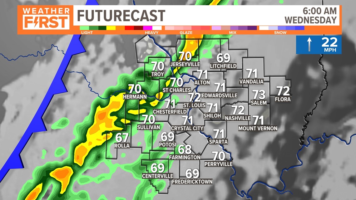
The line should pass through the metro area during the morning rush hour and clear the I-57 corridor in Illinois around lunchtime. The better chance of severe weather with this line should be east of St. Louis.

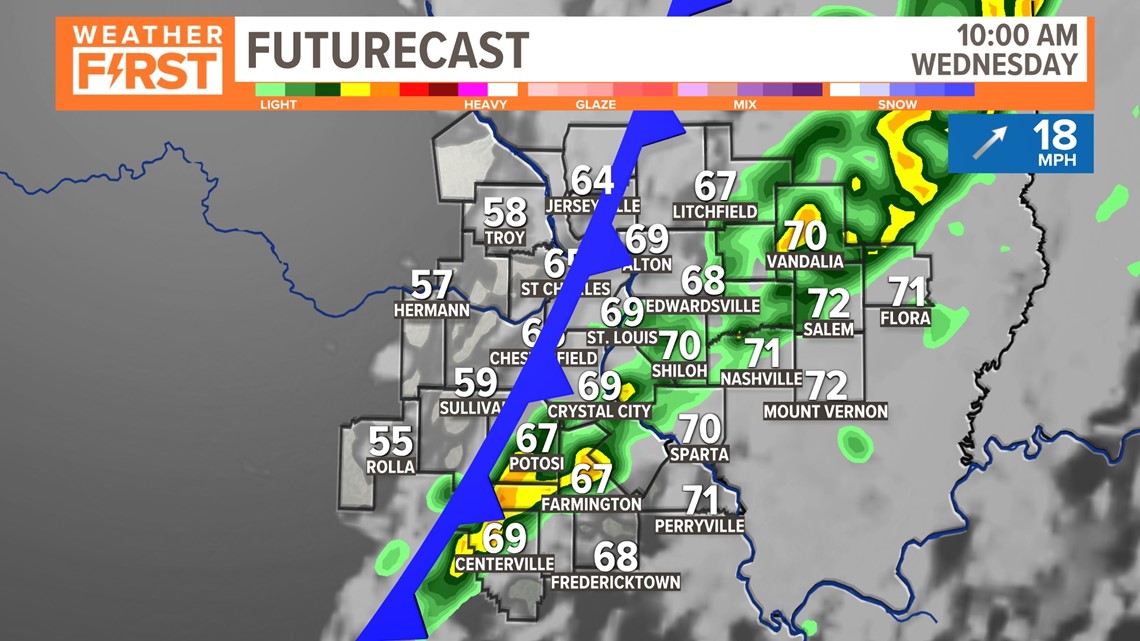
Once the front passes any given location, the threat of any strong to severe thunderstorms will end.

In Missouri, we serve these counties: Crawford County, Franklin County, Gasconade County, Iron County, Jefferson County, Lincoln County, Madison County, Perry County, Phelps County, Pike County, Reynolds County, St. Charles County, St. Francois County, St. Louis City, St. Louis County, Ste. Genevieve County, Warren County and Washington County.
In Illinois, we serve Bond County, Calhoun County, Clay County, Clinton County, Fayette County, Greene County, Jefferson County, Jersey County, Macoupin County, Madison County, Marion County, Monroe County, Montgomery County, Randolph County, St. Clair County and Washington County.