
Wintry weather has arrived in the bi-state with reports of freezing rain and slick roads south of St. Louis before dawn. But with temperatures in much of the area now about freezing, the road conditions have improved.
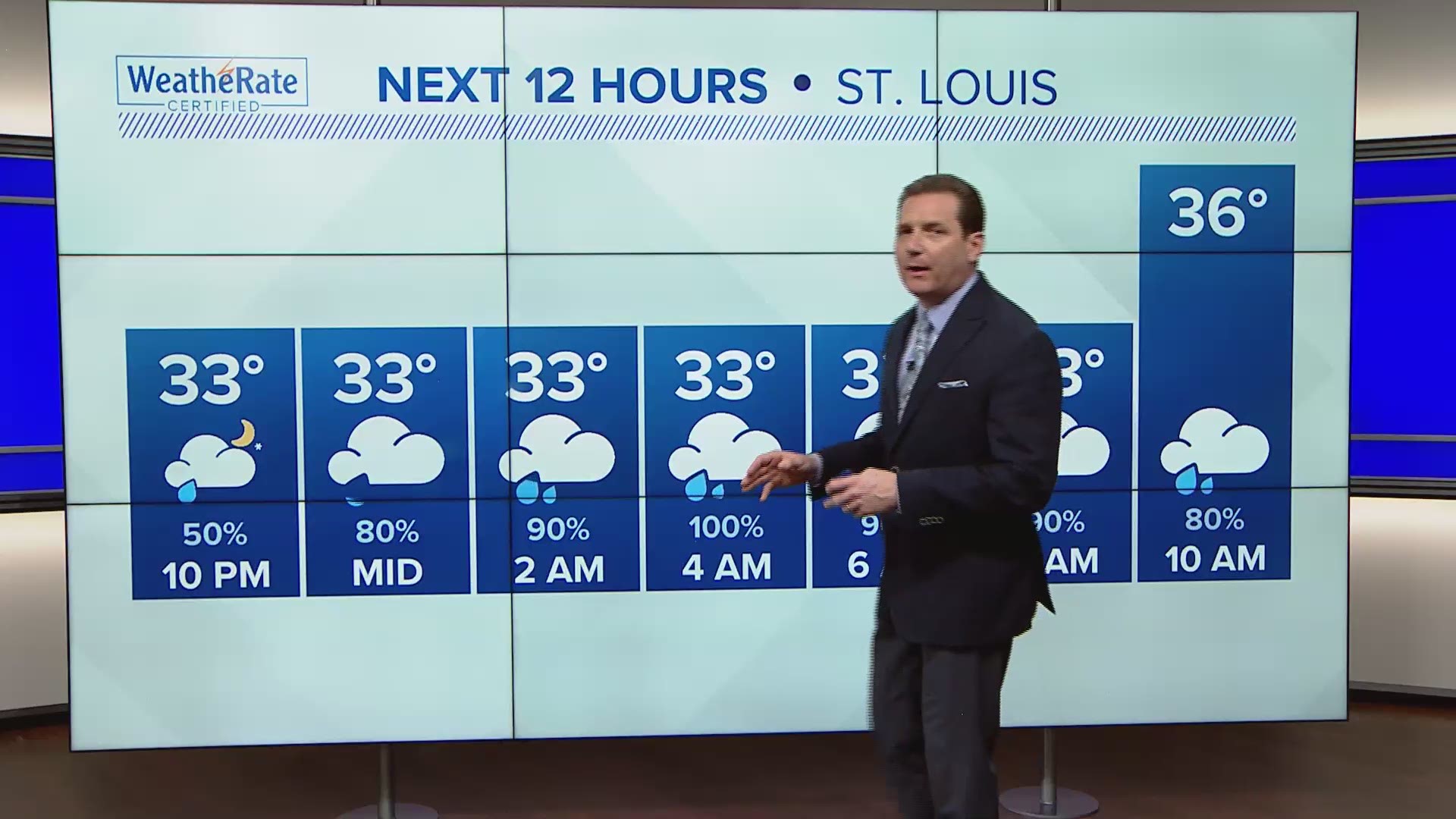
There is a break in the precipitation for most of the St. Louis area, but more precipitation is likely to develop tonight.
LATEST: 5 on Your Side forecast
Most of the metro will get rain as temperatures are forecast to stay close to 33 degrees overnight. Areas north of the metro will be bit colder, and with the anticipation of additional freezing rain and possible sleet late tonight and Monday morning, a Winter Weather Advisory will be in effect from Midnight tonight until 9AM Monday.
A Flood Watch will be in effect from 6PM tonight through late Monday night for the southeast part of our viewing area.
Monday's temperatures will climb through the upper 30s to about 40°. There will be more periods of rain.
Rain chances will continue Monday night into early Tuesday. Temperatures Tuesday will be near average with highs in the lower 40s.
Wednesday is going to be really nice! Partly sunny and WARMER with highs in the lower 50s. Thursday will be mild, but showers will likely develop later in the day.
The icy weather Sunday morning caused nearly 50 road closures and accidents according to the Missouri Department of Transportation.
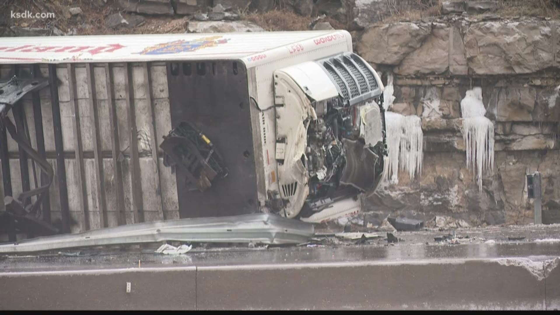
"We expected there to be some snow out there, and then some sleet, and then freezing rain to come down on top of that so that it [the ice] wouldn't be as big of a problem. Well, that all changed at 3 o'clock in the morning when it came in as freezing rain," explained Bob Becker, the District Maintenance Engineer at MoDOT.
The last remaining closure on the major highways is a crash on northbound 270 just before Gravois. The entire road was closed, but not only two right lanes are closed.
The Missouri State Highway Patrol responded to more than 100 crashes from midnight to 3 p.m. Sunday.
Bradley Rogers said it was raining when he went into his overnight shift at McDonald's. By the time he got off on Sunday morning, the rain had turned to ice.
“It’s icy,” Rogers said. “I have a cold right now and it’s not really helping.”
Crews have been caring for the roads all weekend but one of the most dangerous commutes is between your front door and vehicle. A thin layer of ice turned sidewalks into skating rinks.
“I almost slipped 10 or 11 times,” Rogers said.
He said he’s spending the rest of the weekend at home where it’s safe and warm.
You can check the current road conditions on MoDOT's traveler map.
Farther north, temperatures aloft are slightly cooler, meaning our far northern counties will likely see more snow than a wintry mix, with up to 1" of accumulation possible.
South of St. Louis, freezing rain will be the dominant precipitation type, coating surfaces with about 1/10" of ice.
Areas left untreated will be dangerous and slick before temperatures begin to warm up.
A Winter Weather Advisory continues through noon for the entire region.
We'll get a break in precipitation after the first wave, with dry time through the afternoon. Our next batch of precipitation will be rain, with the exception of areas north of I-70 that could see a little freezing rain mixed in late tonight.

