A Blizzard Warning has been extended into parts of the 5 On Your Side viewing area for this evening, and parts of the viewing area are under brief Tornado Warning.
The tornado warnings were in St. Louis County, St. Charles County and Jersey County, Illinois. They expired at around 5:15 after the storm weakened below the threshold of the warnings.
The Blizzard Warning now includes Pike County, Missouri. The warning is in effect until 6 a.m. Monday. The National Weather Service also added the Blizzard Warning to Boone, Audrain and Moniteau counties in Missouri.
Click here for current severe weather alerts.

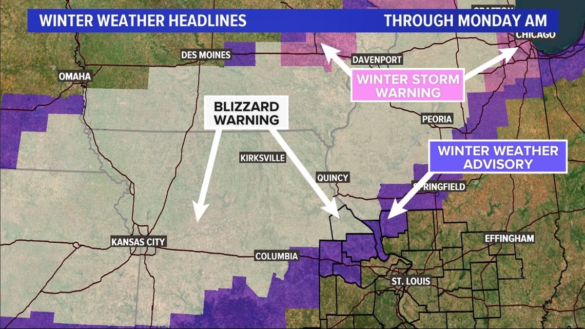
A Blizzard Warning doesn't have to do with the amount of snow that falls, but rather the strong winds that accompany snowfall for an extended period of time. The dangerous combination typically reduces visibility to less than a quarter-mile.
In the area under the Blizzard Warning, winds are expected to be 20 to 30 mph with wind gusts in the 45 mph range. Pike County, Missouri could see 2" to 3" of snow.
A Winter Weather Advisory also is in effect for several counties in the St. Louis viewing area: Montgomery, Warren and Lincoln counties in Missouri and Greene and Calhoun counties in Illinois.
The Winter Weather Advisory means residents of the affected areas can expect periods of accumulating snow that could cause dangerous travel conditions. "Roads may rapidly become slippery once the snow begins," the NWS said.
The areas under the Winter Weather Advisory could see 1" to 2" of snow.
The rest of the St. Louis metro area is under a Wind Advisory from 6 p.m. Sunday through 6 a.m. Monday. Winds are expected to be 20-30 mph with gusts of up to 45 mph. Power outages could happen because of snapping tree limbs, the NWS warned.
Showers will arrive in the St. Louis area Sunday afternoon with temps in the 50s. We won't see a change to snow until later into the evening or overnight hours.
While St. Louis may see a little snow at the end of the system, the chances for accumulating snow are much higher north and northwest of the metro area with an inch or two possible around Bowling Green and Montgomery City Missouri.
We can expect 1" or less in areas north of I-70 in the St. Louis metro area.


The snowstorm is blowing through Missouri and much of the Midwest Sunday, which is one of the busiest travel days of the year.
The storm has packed blizzard conditions in western and northwest Missouri, as well as in parts of Kansas, Nebraska and Iowa.


The arctic air will spill across all of Missouri and Illinois on Monday with high temperatures only in the 20s in the snow covered areas and 30s elsewhere. Winds are expected to diminish during the morning hours Monday as the system pulls away from the area.
5 On Your Side will be tracking the storm and its impacts across the region. Follow the latest forecast here.